|
The City of Bonita Springs Land Development Code contains various property development regulation tables which illustrate development for various zoning districts within the City. Property development tables illustrate development regulations such as (but not limited to):
- Setbacks from lot lines
- Water-body setback
- Road (or road easement) setback
- Maximum height permitted
- Maximum lot coverage allowed
The property development table illustrates maximum lot coverage for various residential zoning designations (percent of total lot area). Note definitions below, relative to lot area, lot coverage, building and structure.
 LDC. Sec. 4-2. – Definitions. LDC. Sec. 4-2. – Definitions.
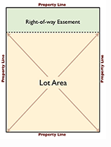
Lot area means the total horizontal area within the lot lines. Does not include right-of-way / street easement traversing across property – if applicable (see illustration on left).
Lot coverage means that portion of the lot area, expressed as a percentage, occupied by all buildings or structures.
Building means any structure, either temporary or permanent, having a roof intended to be impervious to weather, and used or built for the shelter or enclosure of persons, animals, chattels or property of any kind. The term “building” includes tents, awnings, cabanas or vehicles situated on private property and serving in any way the function of a building, but does not include screened enclosures not having a roof impervious to weather.
Structure means that which is built or constructed. The term “structure” shall be construed as if followed by the words or part thereof.
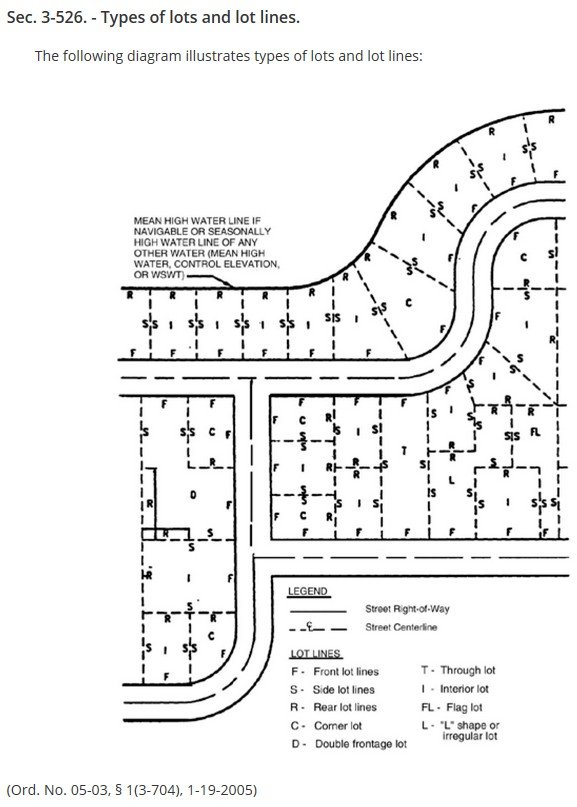
LDC. Sec. 4-400(a)(1) Types and general purpose of districts.
Conventional districts. Conventional zoning districts are districts within the city within which land use is controlled through the regulation of the height and bulk of buildings and structures, the minimum area and dimensions of lots, the percentage of lot coverage, minimum open space and yard areas, through the use of setback requirements, the density of population, and the type and intensity of use of the land and buildings.
LDC. Sec. 9-27. – Definitions.
Easement means a grant of a right to use land for specified purposes. It is a nonpossessory interest in land granted for limited use purposes. Where the term “easement” is preceded by the term “street” or any other adjective, the preceding term describes the easement’s purpose.
Lot, frontage, means the distance measured along a straight line between the points of intersection of the side lot lines with the street right-of-way or easement.
|